 2 Comments
The Clanrye River, running through the centre of Newry has long required crossings. One of the earliest recorded was mentioned by Geraldus Cambrensis in 1178, when a battle between the Irish and Anglo-Normans under John de Courcy resulted in many English soldiers drowning while attempting to cross. It is suggested that, following this loss, de Courcy built a castle near Mill Street to guard the river pass. Tradition holds that this early bridge was likely in the same location as the modern Ballybot Bridge, though it does not appear on the 1587 Lythe map of the town of Newry, which shows a ford in its place. Fords were shallow places with good footing where a river or stream could be crossed.



A new bridge (recorded as the Newry Bridge) must have been built on the same spot by 1642, as it was mentioned as the site of retaliatory executions as a response of the 1641 Rebellion by the native Irish. It was the only bridge spanning the tidal river at the time. In 1673, French traveller, Albert Jouvin de Rochefort, described crossing a wooden bridge at Newry. During the Williamite wars, a Franco-Irish Jacobite force tried to take the town from Williamite forces by crossing the same bridge in November of 1689, but later fleeing when it was felt that they were outnumbered. After a rather violent 17th century, Newry faced a more peaceful 18th century.
The bridge on the 1703 Nevil Survey, is most likely the same 17th century bridge. The survey is the first known to depict houses on the Armagh side of the town, probably the first beginnings of the development of Ballybot. John Francis Small in his book Newriensis describes the bridge at this point as consisting of six arches.
In the early 1700s, a wooden footbridge was built at the ford near present-day Sugar Island. The Newry Inland Canal, developed between 1731 and 1742 created a man-made island, later named Sugar Island, due to its connection to the sugar trade with the West Indies. By 1767 a new turning basin was built, coinciding with the development of the new Ship Canal. The footbridge was replaced by a stone bridge, Mudda Murphy Bridge, named after the builder of the original footbridge.
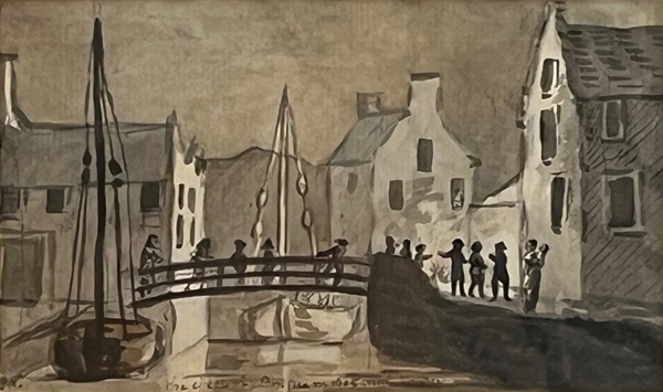
A third bridge was then constructed at the site of the current Dublin Bridge. Both bridges likely coincided with the canal’s development and were referred to by Walter Harris in 1744 as “two handsome stone bridges”, one with six arches on the Dublin Road and the other with ten arches toward Armagh. Later Mudda Murphy Bridge was reduced from ten to five arches, possibly during repairs in 1786. It became known as the Stone Bridge and was described in the 1834 Ordnance Survey as being 80 feet long and 26 feet wide. The Dublin Bridge was rebuilt and improved after being criticised in 1815 for being too high and narrow. It is recorded in the 1834 Ordnance Survey as measuring 80 feet long and 25 feet wide, with three arches.
Harris’s reference to only two stone bridges in 1744, makes it likely Ballybot Bridge was wooden and due to the canal’s development, it is possible that the once tidal bridge was altered to avoid obstructing the canal. In 1751, plans were developed by Needham for a stone replacement, but they were halted, though it is likely that this bridge was completed by 1760. Its reference on the Rocque Map of 1760 as an "Old Bridge" may reflect its longer history as a crossing in Newry. The bridge was described in the 1834 Ordnance Survey as being built of granite, 168 feet long with five arches.
A future article will look at how bridges in the town continued to develop into the 19th century.
The Museum is currently offering free tours of the main exhibition galleries on Wednesdays at 2.00 pm. These must be booked in advance by calling our Education Officer at 0330 137 4422.
Newry and Mourne Museum is open Tuesday – Saturday 10.00 am – 4.30 pm. Please call 0330 137 4422 or email museums@nmandd.org for further information.
Please visit their website at www.visitmournemountains.co.uk