
 Write a comment

Newry and Mourne Museum has a collection of several hundred photographs of the local area taken by Cecil F.S. Newman in the late 1960s and early 1970s. The photographs were taken to provide illustrations for the Mourne Survey, published in 1970 and the Newry Area Plan, published in 1973, both of which he authored.

The Mourne Survey was carried out in consultation with a number of authorities and organisations with an interest in the area, such as the South Down and Mourne Tourist Development Association. At the time, the Mourne area was becoming a growing centre of attraction for tourists. It was understood that the recreational potential of the area needed to be developed, and facilities provided for the growing number of visitors, whilst also protecting and conserving the landscape.
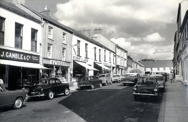
The Newry Area Plan covered a large area from South Armagh to the Mournes, including Crossmaglen, Rathfriland, Newry, Warrenpoint and smaller settlements such as Hilltown, Poyntzpass and Meigh. It included information on land use, population, housing, employment, transport, shopping, public services, education and recreation. The Plan was published at a time when a number of major schemes were in progress in the area, including the development of facilities at Warrenpoint Port, the building of the dual carriageway between Warrenpoint and Newry and the second stage of the Newry throughpass at Abbey Way.
Newry was one of the key centres selected for special attention in the Northern Ireland Development Programme 1970-75. The Area Plan was a means of providing the framework for further projects, to improve the area for local residents, as well as presenting the locality as attractive to tourists and highlighting its potential to industrialists.
The author of these reports, Cecil Newman, was born in Lisburn in 1914, the son of a Royal Ulster Constabulary policeman, whose family came from a farming background in West Cork. He worked in the surveyor’s department of Belfast City Council before enlisting as a Royal Engineer in 1940, achieving the rank of Major by the end of the Second World War. After the war ended, he worked in Berlin for two years, helping with the reconstruction and re-establishment of the water supply. Gaining a qualification as a planning officer in 1957 he joined the Northern Ireland Civil Service as Superintending Planning Officer in the Ministry of Development. It was in this role that he was involved in the production of the two reports.

He had been a keen photographer from an early age and an Associate of the Royal Photographic Society since the 1940s. During the 1970s he concentrated on aerial photography, using his army connections to enable him to travel as a passenger on training flights over Northern Ireland in Sioux helicopters.
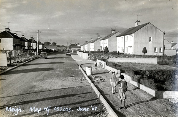
With an interest in rural as well as urban development, Cecil Newman became a leading member of the Ulster Society for the Preservation of the Countryside and was Secretary of the Mournes Advisory Council. He owned a holiday cottage at the head of the Slievenaman Valley in the Mournes, where together with his wife Mollie and children Pat, John and Michael, the family enjoyed walks in the mountains. His photographs, taken over fifty years ago, provide a walk down memory lane of the towns, village and rural areas of the local area.
More photographs from the Cecil Newman Collection can be viewed on the NMD Museums website www.visitmournemountains.co.uk and searching ‘Newman’.
Newry & Mourne Museum is open from Tuesday to Saturday, 10.00am - 4.30pm. Free tours are available on Wednesdays at 2.00 pm, which must be booked in advance by calling their Education Officer at 0330 137 4422.